Azad Kashmir District
  Introduction
  Bagh District
 

Bhimber District

  Kotli District
  Mirpur District
  Muzaffarabad
  Poonch District
  Sudhnuti District

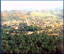
Bhimber District

Bhimber district was carved out of Mirpur district in 1995. Prior to this it was a sub-division (Tehsil) of the Mirpur district. The district is bounded to Mirpur district in the northwest, shares borders with occupied Kashmir in the east. It is bounded to Pakistan in the west and south. Total area of the district is 1516 square kilometers and is divided in three tehsils. According to 1998-census total population of the district stands at 297,000 while its population according to 1999 projections is approx 303,000. The area is very rich in archaeological remains. Bhimber falls on the route that was followed by the Moghul rulers of India for their frequent visits to the Kashmir Valley.

Jandi Chontra
Jandi Chontra is a scenic spot located 17Km from Bhimber and 67Km from Mirpur district. The area is known for its panoramic views. The Shrine of the Sufi Saint Baba Shadi Shaheed is also located here.

Baghsar Lake
Baghsar Lake is situated at 975m above sea-level in the Samahni valley. The Sar, local name for a lake, is nearly half kilometre long sheet of clear water that soothes the senses of the visitors.

Mughal Fort
A Mughal Fort is situated on top of a hill in Baghsar. The Fort over-looks the Sar Lake that adds grandeur to the area. This four storey massive structure of granite is a feat of Mughal engineering that has stood the ravages of time. It has also played important roles in history during the times of Ahmed Shah Abdali, Ranjit Singh and Gulab Singh. It is said that the Mughal Emperor Janghir, on his way back from the Kashmir Valley, fell ill and ultimately died in this fort.

Area 1516 square kilometers
Population 303,000

Return to Top


Copyright © 2000-Presen, Kashmir Valley, All rights reserved.